Sept 4
I picked the right day to hole up in a motel. Horrid day yesterday. Driving cold rain and screaming N wind. Summer is over here in the N woods. Only sprinkles this morning, but the N wind is still blowing. The upside is that this storm will wreak havoc on the bugs. I believe for every drop of rain that falls ... another mosquito gets snuffed! Mother Nature has delivered a hammer blow against the bugs. When I got to Wisconsin I made a vow that I would personally kill every mosquito in the state. This proved unrealistic. But what I could not do Mother Nature did for me. I am refreshed, shower, clean clothes. Not s single mosquito bite yesterday!
I will head N and E, towards the Menominee R, which is rumored to be a great SM stream. On the way I will pass by Afterglow Lake. Bert Moline was my grade school shop teacher, until he quit his job, bought all the property around Afterglow Lake, and built a resort. My family were among the first customers, and went there for vacation for a number of years. I have not been there for over 40 years. I head NE from Eagle River to Phelps, then follow my intuition until I come to the sign.


Afterglow is only a few miles from Lac Vieux Desert, the source of the Wisconsin River. We are up in the high country now, near the continental divide. I drive up to the lake, and stop in at a bait shop to ask directions. In the bait shop is the mount of the world's largest tiger musky, caught years ago out of the lake. (A tiger musky is a cross between a musky and a pike.)


I follow county Hwy E back to Hwy 45, the same hwy that ran 1/2 mile west of my childhood home in the suburbs of Chicago, where it is called La Frange Road. Only 2 miles downstream of its source, the Wisconsin R is already stained dark brown with tannins leached out of the swamps that surround it.


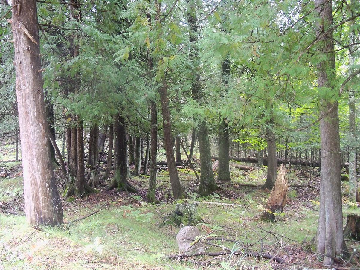
I head N on Hwy 45, to the border between Wis and Mich. Almost all the old growth in the white pine belt was either logged off or burned. Straddling the state border is the Sylvannia Tract. This is a large acreage of lakes and forest that was once owned by a group of wealthy industrialists, who used it as their personal vacation playground. In more recent years it was donated to the government, which converted it into a park.
Pete Moline told me of a dead end road I can follow that leads to a trail into the woods, where I can walk into virgin white pine timber. I follow his directions thru Land o' Lakes, and find the trailhead.

I hike in. The first thing that jumps out at me is the amazing quantity and variety of mushrooms. You don't see this in second growth forest. I took these pics in about 10 minutes walking along the trail.


On the trail I meet a guy about my age coming the other way in a wetsuit. Seems slightly out of place here. He says he started at the other end of the trail and snorkeled thru all the lakes, hiking the portages along the way. Does this every year. 10 miles. The water is warm but really clear. You can see bass 20 ft down.

Then I head N again on Hwy 45. Into the UP now. In a few miles I come to the crest of a hill. No signs, nothing unusual about this hill, except that once I cross over it I leave the Wisconsin River watershed and enter the Ontanagan River watershed. The Ontanagan flows N into Lake Superior. The Bullship has now entered the 5th great watershed on its journey. Began in the Columbia, then up into the Fraser in BC, then crossed over the Colorado, then into the Mississippi, and now into the St Lawrence.

I stop to get my picture taken.

In a few miles I come to Watersmeet, Mich. This marks the northernmost point on my journey. Like the John Ross expedition to find the Northwest Passage, I am turned back by ice and cold. In their case, arctic pack ice, in my case sleet on my windshield, which is anathema to the wily bass. I turn east on Hwy 2. Soon I cross the Paint R.

The Paint flows into the Brule R, which forms the Wis/Mich border.

The forest is almost all pine here, no agriculture anywhere.

I head on to Iron River, then turn S on Hwy 189, which crosses the Brule back into Wis.


I spend he sunset hour driving around and exploring. Stop at a tavern for dinner, and check the internet for bass fishing reports. The thing that brought me here was the website of fishing guide Mike Mladenik:
I find that the internet chat suggests that the river around the Sturgeon Falls Dam is supposed to be one of the hottest spots, and that is exactly where I am. I get them to turn on the U of Oregon football game. I warn all the cheeseheads looking at other games on other TVs that the Ducks are going to be tough this year. Even tho they have suspended their star running back for this opening game against New Mexico they squeak by for a close victory, 72 - 0.
Sleep in the Volvo Hotel at a wayside near Niagara, Wis.
Sept 5
I awake and realize that I left the car window open a crack last nite. Since I crossed the Missouri R in S Dakota, this is the first time I have been able to leave a window open. No moquitos - unbelievable! I drive around Niagara. There are cliffs along the river here, something I never saw along the Wisconsin or Chippewa.

The paper mill in Niagara is belly up. It is an old mill that could not stay competetive with the giant new mill on the Michigan side of the river.


I drive across to the Michigan side, past the humongous new Verso mill.

There is a mining museum here - not open yet, but I stop to take a couple pics.


Then I see a sign for a boat launch. After a 1/2 hr I find the launch, into the Sturgeon R, just above its confluence with the Menominee.

There is a mourning cloak butterfly that keeps hanging around a tree in the middle of the parking lot. I spend a lot of time trying, but I cannot get a clear pic. This is sure sign that summer is over. You never see mourning cloaks except at the very beginning of spring and very end of summer. I always feels sad when I see them late in the year, as if they are mourning over the impending death of the growing season.
I head out onto the water, which is backed up into a reservoir by the Sturgeon Falls dam just downstream.

I spend an hour scouting around. It is very shallow, and I head upstream until I can go no further. I fish a bit. No bites. Good thing that I get out of here. I have a Wisconsin license, which is good for boundary waters between Wis & Mich. Valid in the Menominee, but not here up in a trib on the Michigan side.


I head down under the bridge towards the Menominee.

There is very little flow in the big river, and lots of weed beds.


Some large backwater areas are flooded. Looks like ideal LM habitat. they MUST be here. The automatic lens cap on my camera is sticky with the juice of Chinese food that I dribbled on it. Will not open all the way. Do not drip Chinese food on you new camera!

I catch a small lucius.

Then check out some more backwater areas as I head upstream.

I was looking for a free flowing wilderness river, but this area is just a big still pool with suburban houses and boat docks along both sides of the river.

There are zebra mussels all over the bottom.


I catch a small SM.

Then head all the way up to the Hwy 8 bridge. Still no shallow water or rapids, so I turn back. Near the boat ramp a hang glider swoops over.

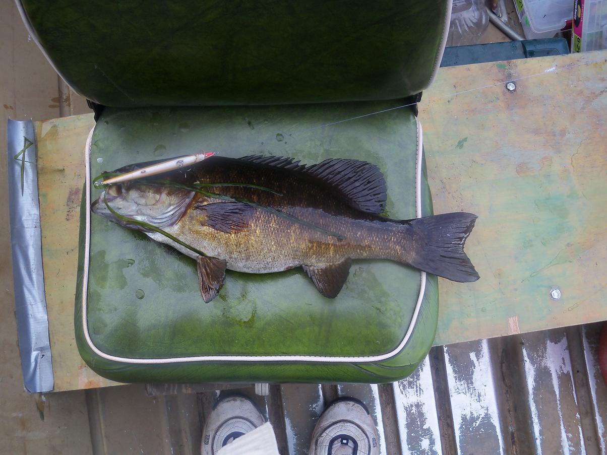
I catch a nicer SM, and miss a couple bigger fish.

I drive into Norway, Mich, to have dinner at a tavern where I can watch the SF Giants baseball game. But I realize I am in the central time zone now - the game does not start for another 2 hrs! So I go back out on the lake. I noticed a rock bar coming out from shore. Gotta be SMs here, and just before dark I get a beauty, biggest of the day.

An intersting day on the water. I have lined up some good spots to fish tomorrow. Mother Nature did not quite complete the job. There were 2 mosquitos I saw today. Not aggressive. Dazed, like shellshocked survivors of a WWI battle. Tomorrow should be a good day.
Sept 6
I head out at dawn. I will run upriver and stop at the good spots I picked out the day before. The first one draws a blank. But the 2nd produces a nice LM. Knew they had to be here!

The LM was hanging out at the mouth of this side channel.

Then I get another snake northern in a side slough, and miss a bigger one in the next slough.

I run all the way up river past the Hwy 8 bridge until I hit the rapids. Not what I was hoping for. No long run of flowing river I could navigate with the Bullship. Just a big rapids dumping into a long slackwater flowage.

This is the end of navigation for the Bullship. They call it Piers Gorge.

I float down from the rapids, shorecasting with the rap. Slurp! I get a beauty SM. A minnow compared to the one I lost on the W fork of the Chip, but still the 2nd largest SM caught on this trip so far.


I run back down to the launch. The bite is on, although I have hardly fished I have gotten surface hits everywhere except spot #1. Instead of heading right back down to the launch I decide to run down and check out the dam. Turns out that the dam area is steep and rocky, ideal SM habitat. Must stop and fish here. I get hit right away. The perils of being too aggressive: this bass jumped the shark, rocketed straight out of deep water and missed the rap on the way up, but landed right on top of it on the way down, and hooked itself in the butt. I thought this was a much larger fish until I saw that is was hooked amidships.

Then another beauty on the next cast. All fish caught on surface hits this morn.

The channel gets very narrow just above the dam. Should be the widest part of the lake, but you can cast across from shore to shore here.

The rap is not particular about what it catches. This SM is smaller than the lure it bit on.

Should keep on fishing, but I decide to load out and go exploring for better water instead. As I load the boat out there is a Michgan conservation officer checking boats. I begin to panic. Must be something I am doing that is illegal. But I pass with flying colors. Good thing he was not around yesterday when I was fishing for a little while in the Sturgeon R mouth without a Michigan license.
I drive downstream and find the road down to the Sturgeon Falls dam, above which I was just fishing.

Too shallow to use a motor here.

The water is slightly stained, but very clear. You can see down about 6 ft - a far cry from the Wisconsin and Chippewa where you are lucky to be able to see 18" down into the black murk. I like the looks of this river!

Oddly enough, there do not seem to be any zebra mussels here. Why?
I drive on down about 5 miles and find another boat launch. The river looks absolutely great here. Slow flowing and clear. Deep enough to run with with motor, and clear enough to see the rocks before you hit them with your prop. A couple bait chuckers are fishing with night crawlers on the bottom. One of them is reeling in a 2 lb SM as I arrive. Just a midget compared to the ones we were getting yesterday, he says. I like this spot! Big bass are swirling in the shallows, so I walk downstream and throw the rap around. I get a big bull rush from a bass, but it turns away.

The SM grows slowly here in the N Woods. Some people say the SMs on Van Isle never get more than 10-12 years old. Not here:

This is what I have been seeking since I left OR. A trophy SM stream I can run safely in the Bullship. I am excited. Should launch and fish right now, when the bite is on. But instead I head back to town. I will have dinner, watch the baseball game, check out this part of the river in Google Earth, and come back this evening. Then float this section tomorrow.
Near Norway is a cool spring, where I refill my water bottles.


Then I head over to the Big 10 Sports bar, where I have dinner. The Giants game goes on forever. 0-0 tie until the 12th inning when the Gigantics finally pull out a win. Only 1 game out of first place now. Since the Cubs are so awful this year I need another team to root for. Before I leave I ask the barmaid what the weather report is predicting. She says 40 percent chance of rain. She is really cute, but I do not trust here weather judgement. Sure looks like rain to me.
On the way back to the boat launch it is already starting to drizzle. Dark black clouds are approaching from the W. I had planned to set up my tent at the launch, but it is raining steady when I get there. I wimp out and sleep in the car instead. After a couple hours of rain it begins to flash lighting and the rain pounds down. I am huddled under my blanket when a stick of dynamite explodes next to my car. No - it is a lightning bolt. Very close. The rain pounds down hard all nite. Should have gone out fishing this afternoon, when the weather was good and the bite was on.....
Sept 7
The rain has stopped. I back down to the launch, but something is wrong. The big river is way up. Stained dark, dark brown now. Running fast, with its surface covered by patches of eelgrass ripped off the bottom by the risng flow. I wander around, stunned. Everywhere I go in this state that has suffered from 8 years of drought I am caught up in floods. I stay for an hour and half, amazed by how fast the big river is rising. It comes up over a foot as I am watching, right up over the walkway people were fishing off of yesterday afternoon, when it was 18" above the water.

I try throwing the spook out, but it is instantly fouled by drifting eelgrass. The wind is abosutely howling out of the NW, and cold scud clouds are racing over the trees. Classic post- cold front conditions. Useless to fish today. Missed my chance yesterday afternoon. Should have gone out when the water was low and clear, and the bite was on.
I have a habit of kicking back and relaxing when I get into good fishing. Need to be more dedicated. To drive all this way and waste my chance is a bummer. Very difficult to drive out into the blind and try to run these rivers full of current and submerged boulders when the water is high and fast. Could easily come to grief. Better safe than sorry. Reluctantly I leave the river without even launching the boat. I will spend this day exploring this lower part of the watershed, where I have never been.
I head off to the S and E, driving down little dirt roads looking for boat launches. No luck. I end up in a forest of cedar. I can smell it. Brings back memories of Van Isle, where the cedars are 10 ft thick. The natives called it the Tree of Life there. Made their houses out of it. Made their canoes from its trunks. I made my living for so many years sawing and splitting its wood. The cedars are tiny here, but amazinngly similar otherwise.

I pick a cedar frond to carry along with me on the dash, and drive off.

I cross the Menominee again on the Hwy Z bridge into Wis. Surprisingly, the flow is fairly low here. They must be holding that flood flow back above the dams upstream.

Back out to Hwy 41 at the tiny town of Carney, where they have a cedar mill. But these logs are SO tiny.

I turn S on Hwy 41, then turn E on a little county hwy at Stephenson. Soon I hit the W shore of Lake Michigan. The lake of my youth. The lake from which the wind would turn Wrigley field from a hitter's park into a pitcher's park. Supposed to be great fishing here nowadays. But not today. The wind is screaming, and the waves are big and rough. No place for a Bullship to be today.

In the distance you can see the Door County peninsula in Wis.

There is a cool variety of beach grass growing 8 ft tall out of the puddles among the low dunes.

The tourist towns like Hayward and Eagle River seem to be booming, as always. But no tourist ever sets foot in the Menominee. The industry towns that the tourists shun seem to be really struggling in the "current economic situtation". Even the local space exploration industry is rusting away.

I finally reach the twin towns of Menominee, Mich, and Marinette, Wis, at the mouth of the river. The lower end is very industrial. It is so windy it looks like it might snap off the flagpoles.


In town I find a Verizon office and cancel my contract with them. Biggest mistake I made on this whole expedition. I was hoping to be able to connect to the world wide web while I was in my boat out on the river. But their coverage does not seem to extend beyond the city limits anywhere. I wasted $800 on these jokers, to get something I can get better for free from McDonald's or most any coffee shop. Good ridance. While in town I connect to the web, and check out Google Earth - the Fisherman's Friend. I see roads that seem to lead to boat launches where I could find none while driving around this morning.
There are snowy egrets fishing in the shallows.


The first dam on the river is a couple miles upstream. Famous walleye water here. The big eyes come up out of the lake. Two guys have kayaked out to a midstream island to fish.

I drive upriver from Marinette, looking for boat launches. The river is very shallow and wide, much like the Wisconsin below Merrill.


There is an intersting sign about the history of the forest industry.

Finally get back to Hwy Z, where I crossed the river this morning. I drive down a tiny dirt road and find a launch site that I passed by this morning. A great looking spot. Upstream is a big rapids.


This is called Pemene Falls. (Pronounced like "Bimini")

This is the reason I do not like going out on rivers like this without checking in Google Earth first. I do NOT want to be going down Pemene Falls, or anything like it, in the Bullship.


Here is what a kayak website has to say about Pemene Falls:
"This is easily one of the scarier rapids that I have run. It consists of 4 main features, which I will describe in the order you encounter them while running the rapids.
There are some sweet smaller surf waves leading into the main drop. The first large feature, Clarice Hole is an extremely violent river-wide hole where the river narrows to 12' wide. It flushes in the center. When entering the hole from upstream, the top of the backwash is a little above eyeball level. There is a small room of doom to the right, which (if you flip and are swept into) will make your life miserable. There are countless sharp pointy rocks (that the current will slam you against) as you set up for a roll. A word of caution: this is where Pemene Dam used to be. It has been my experience that at levels above 7.9 feet you can safely run this rapid without the risk if hitting rebar. However, I have not been able to confirm presence or absence of rebar risks at levels below 7.9 feet. Also, the hole becomes less flushy the lower you get. I have not visited "The Lambs" any higher than 8.3 feet (which is a good level to run it at), but I was told that it was very intimidating at 12 feet.50 yards downstream is Hannibal Hole. This is a great hole to play in, especially since there is a huge eddy on river left that provides easy access. Just 5 yards below Hannibal is Lecter Wave. This is one of the best waves in the Upper Peninsula/Wisconsin area in my opinion. A huge eddy on river left provides easy access.
The 4th feature of this rapid is known as Cannibal Rock. It is a chunk of old dam on the river right side of Lecter Wave. This rock is just below the surface and if you windowshade here, you will smack it hard. (I received a mild concussion the first time I hit it, and spent the next 12 hours vomiting. Plus it snapped my paddle in half!)"


There is a back eddy below the falls that looks killer for SMs and eyes. Would like to fish it, but I don't want to puke for 12 hours to get there. Better to come up from below tomorrow morning.
I find a nice campsite near the falls. Tomorrow morning I will launch and fish here.

Sept 8
Dawn is clear but still very windy. Post cold front conditions again. The pines here are even bigger and taller than the ones I walked thru in the Sylvannia Tract.

There is a memorial at the launch site for Gerald Welling, so later I google his story. He was run down and killed in the line of duty by bear poachers.

I am excited about getting upstream and fishing below the falls. But I linger around my campsite, rebuild the fire and make coffee instead. Good thing I did not try to motor out in the dark. Again, the river is way shallower than it looks. Immediately I must tilt the motor into shallow drive. Rocks everywhere. Water is still high, and stained very dark compared to the other day. I spend an hour creeping upstream, but there is a riffle beneath the falls pool that is too shallow for me to cross. Need to wade here, and pull the boat up behind me. But I start drifting down instead. The high water has ripped immense quantities of eelgrass off the bottom, and the surface is covered with it. Cannot retrieve a rapala, or any other lure, more than 20-40 feet without getting fouled. Very hard to control the boat in this wind. Nothing at all biting on the surface after this cold front. I finally get into a few fish downstream from the launch.


Then I give up. Just too hard to fish under these conditions. Should have been here a couple days ago. I load out and head upstream in the car, exploring for more launch sites. I have seen the entire river now, from its beginning to its end at Lake Michigan. This is definitely the prime area I have seen for fishing. But the high, stained water, drifting eelgrass, and constant wind make it almost impossible to fish.
In the evening I decide to go back to the top end of the Sturgeon Falls Res, where I fished the other day.
I caught good fish on surface hits at every spot I tried then, and the water is deep there. And I will not get swept down into some horror rapids like Pemene Falls. But the evening bite is dead. Cold front has killed the fishing. All I can muster is a couple of snake northerns.

There is a boat with 3 guys fishing as well. Like me, they say they were catching fish like crazy on Labor Day, before the weather turned. But tonite they cannot get a bite.
I sleep at the launch below the rapids, which is called Piers Gorge.
Sept 9
The day dawns clear to bluebird skies. I go back out and fish the same pool, with the same results. Not even a single bite.

The upside is that there is no longer a single mosquito alive in N Wis. Mother Nature has completed one of the greatest mass exterminations in history. Makes Adloph Eichman pale in comparison. Billions and billions of these nasty bloodsuckers snuffed without a trace. Good riddance. If I ever get promoted to a position where it is part of my job description to design new universes, moquitos and poison ivy are 2 life forms I will leave out.
I need another break and a shower, so I head back in to Iron R, where Motel 6 has reduced their rates to $40 / nite. Like Lewis and Claude did when life on the trail got a bit tedious, I will relax and watch a FB game. On the way I pass by a strange looking rig.

By some coincidence, this seems to be the only Rotochopper B66 driving around town today, just as I seem to be the only Oregonian towing a bass fishing rig around. I spend 15 minutes walking around it, trying to figure out what it does. Whatever it is, its mission in life is obviously to turn big pieces of wood into little pieces of wood. And it is a mean ass piece of work. Finding yourself in the inbox of the B66 looks like even less fun than being in the inbox of Pemene Falls. At the motel I google for the Rotochopper:
http://www.gemacosales.com/products.php/rotochopper_dieselpowered_wood_grinding_systems/15
http://www.youtube.com/watch?v=d6IpqqlcYbw
Would love to see a battle to the death between N.N. Horse's giant musky and a rotochopper. Would male for a good sci-fi movie, like the classic Killdozer....
I shower and blog, and spend a refreshing nite in the motel.
Sept 10
I leave the motel and get back out to the river around 1 PM. It is down a bit, but still running dark and high. The mid channel rocks I remember from before the rainstorm are under water and not visible. Two days ago I could see 4 ft down into the water, now barely 2 ft. Could see the rocks coming before I hit them. There was no wind, so I could see the swirls of rocks that were just underwater. Today it is windy. Cannot see the swirls, and cannot see the rocks coming. I launch and begin creeping upstream, running the sounder continually, motor tilted into shallow drive mode. I still hit boulders, invisible, coming up out of 4 feet deep water. I must find deeper slots and creep up thru rapids without destroying the prop.


I stop and walk around at the big bend, taking a few pics.


Gotta be fish here. Finally I begin fishing. On my 3rd cast I catch a bigger fish then either of them did on their long float. I will teach these cheeseheads how to catch the wily bass.


Even on the way back down I can only idle in most places, and push my way over the shallows with my oar. It is dark by the time I get back to the launch.
I can't understand why the reservoir above Sturgeon Falls dam is full of zebra mussels but there do not seem to be any in the river jsut downstream. Also, I have not seen a single live crayfish in this river, where there were thousands in the Wisconsin. Why?
This is the finest river SM habitat I have ever seen, anywhere. Would love to get out onto this river when the water is low and clear, and it is not windy. Had my chance the other day, and went to the pub to watch a baseball game instead. The chance will not come again this year. There is another front coming. Rain tomorrow. This is it. I will head downstream before the rain sets in tomorrow. There is a RR bridge and big island I want to explore
Sept 11
The dawn is cloudy and calm. Should go right out and fish, but I linger in the car for a half hour. As I walk the 100 yards to the boat the first drops of rain start falling. Then harder and harder. This is not a thunderstorm. It is a slow moving cold front. Gonna rain all day. Time to leave this big rocky river. A person could do some serious business with the wily bass at the right time on this river. Hope to get back some time.
I head back to Motel 6. Like Lewis and Carlos, I must take advantage of the winter discount rates. Plus, the Oregon football game is on TV. Lewis and Carlos were not Ducks fans, because Oregon had not been created yet.
At the hotel I shower, watch TV, and try to decide where to go next. Like Lewis and Colin at the 3 Forks of the Missouri, I must make a choice" N, S, E, or W? I would like to try Lake Michigan for SMs. I learn that today is the day of the 20th annual Sturgeon Bay Open bass tournament. It took an awesome average of over 5 lbs to win the spring tourney. I must go up and check out this spot, even if it is too windy to fish.
In the evening the Ducks are bumbling idiots to begin the game. Trail 13 - 3 to a not very good Tennessee team when the game is suspended for an hour by a horrific lighting storm. Probably the same one that hit me on the Menominee, now headed S. After the interruption Oregon comes to their senses and crushes the hapless Vols with 45 unanswered points.